Auburn's Joint Land Use Study
View the final Joint Land Use Study and associated documents, or view the Joint Land Use Study - Executive Summary.
The Joint Land Use Study between Mount Apatite Recreation Area and the Maine Army National Guard Training Facility located off Garfield Road in Auburn was funded by the Office of Economic Adjustment (OEA) in a grant to the City of Auburn. The primary goals of this study are to ensure the continued operational utility of the military installation and to support the appropriate public uses of the Mount Apatite Recreation area now and in the future. The JLUS is expected to result in recommendations to the Auburn City Council to amend the comprehensive plan and land use ordinance assuring mutual compatibility among the Training Site, the Mt. Apatite Recreation Area and surrounding areas of the City.
The proposed study area, which may be refined, is the area between Hatch Road, Perkins Ridge Road, Young’s Corner Road, Hotel Road and Minot Avenue (Route 121). 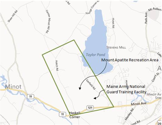
The City has elected to manage this study process by creating a Mayor-appointed Policy Committee. The Policy Committee has been appointed and will oversee and guide the work of the consultant hired to prepare the necessary information to meet the goals of the study. Click here for Policy Committee meeting dates and members.
Please check this website and the Auburn Maine JLUS facebook page for news and updates, the latest information being discussed and to provide feedback on ideas being discussed.
Support Staff
Kat Beaudoin A.I.C.P.
Integrated Planning Solutions 207.446.8099Eric Cousens, Planning Director
City of Auburn, Maineecousens@auburnmaine.gov207.333.6601 ext. 1154
© City of Auburn, Maine. Privacy Policy | Terms of Service